


The 'RoadTracer' Mapping Program Offers Unprecedented Precision
Rahul Kalvapalle — April 20, 2018 — Tech
References: news.mit.edu & newatlas
A group of scientists and researchers at MIT's Computer Science and Artificial Intelligence Laboratory have developed a high-tech mapping system that revolutionizes the way photos and images are analyzed, with the end result being maps of unprecedented precision and boasting incredible attention to detail.
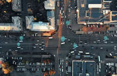
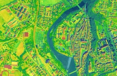
The so-called RoadTracer mapping system utilizes neural networks to spread out its monitoring, starting from a single location before dispersing outwards. The computerized system is capable of taking aerial images of cities before building out its maps in an accurate and steady manner. So far, the system has been trialed using images from over 25 cities, with the number set to expand in the near future.
With a significantly better accuracy rate than conventionally computerized mapping systems, RoadTracer is bidding to revolutionize high-tech maps, and holds promise for adoption in a range of industrial and scientific applications.
Trend Themes
-
Neurally Networked Mapping Systems — Revolutionizing the accuracy and detail of maps using neural networks.
-
High-tech Map Accuracy — Improving mapping accuracy rates with computerized systems.
-
Industrial and Scientific Applications of Roadtracer — Expanding the use of RoadTracer beyond mapping.
Industry Implications
-
Map Technology — Developing more accurate and detailed mapping technology.
-
Aerial Imaging — Innovating aerial imaging technology for precision mapping.
-
Urban Planning — Using RoadTracer to improve urban planning and design processes.
2.1
Score
Popularity
Activity
Freshness