
The installation of Bloomington's first tactile map at Switchyard Park represents a meaningful advancement in municipal accessibility efforts. The venture demonstrates how thoughtful design can foster independence for visitors with visual impairments.
The tactile map at Switchyard Park figures as a navigational aid with multiple sensory elements, including tactile surfaces, braille labeling, and high-contrast colors. These are intended to provide comprehensive orientation within the 65-acre park space. The tactile map's prominent placement near high-traffic areas ensures visibility while symbolizing the city's commitment to universal design principles that serve diverse community needs.
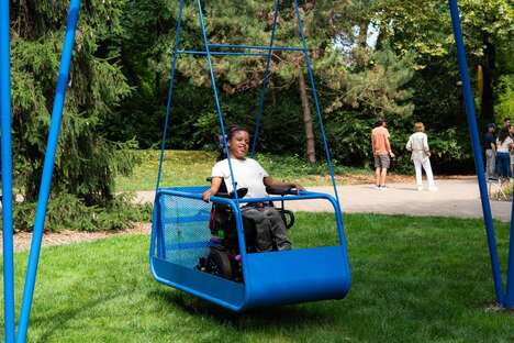
The project forms part of a broader, well-funded initiative by Bloomington Parks and Recreation to enhance inclusivity across the city's public spaces. This move is evidenced by recent accessibility upgrades ranging from wheelchair-accessible shuttle services to adaptive playground equipment and infrastructure improvements.
Image Credit: City of Bloomington
Key Themes Behind This Trend
- Inclusive Urban Navigation
- The development of tactile maps in public spaces illustrates a trend towards making urban environments more navigable for individuals with visual impairments.
- Multi-sensory Wayfinding
- Emerging wayfinding aids that incorporate tactile, visual, and auditory elements provide more comprehensive navigational assistance for people with diverse needs.
- Universal Design Commitment
- Public infrastructure projects that prioritize universal design principles are shifting urban planning towards more inclusive community experiences.
Where This Applies
- Accessibility Solutions
- The creation and deployment of tactile maps are driving innovation within the accessibility solutions industry, fostering new approaches to inclusive design.
- Urban Planning and Design
- As cities invest in universal design, the urban planning and design industry is presented with opportunities to integrate accessibility features into public spaces.
- Assistive Technology
- Assistive technology is being redefined by the implementation of multi-sensory tools like tactile maps, which enhance the navigational capabilities of visually impaired users.