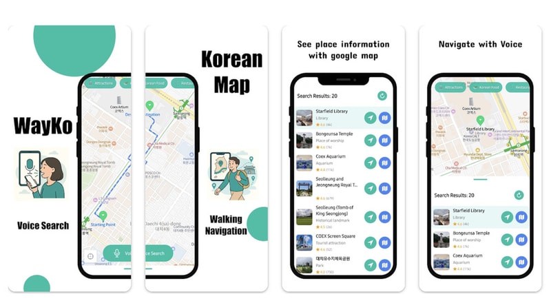
WayKo is a navigation application tailored for travelers navigating South Korea, addressing limitations in existing mapping services. Unlike global platforms such as Google Maps, which restrict certain walking routes due to security concerns, and highly localized options like Naver Maps, WayKo integrates accurate walking and transit directions suitable for a wider audience.
The app supports voice search in multiple languages and incorporates tag-based place discovery, enabling users to identify points of interest efficiently. Additionally, it integrates with Google Maps for broader context and route validation. From a business perspective, WayKo illustrates the value of region-specific navigation solutions that combine local expertise with global technology. By filling gaps left by mainstream mapping services, the app offers a practical tool for both tourists and expatriates seeking reliable mobility information in South Korea.
Image Credit: WayKo
Key Themes Behind This Trend
- Localized Navigation Platforms
- Region-specific routing that accounts for local regulations and pedestrian accessibility opens opportunities for platforms optimized around national and cultural context.
- Multilingual Voice Search for Mobility
- Support for multiple spoken languages in navigation experiences enables more inclusive wayfinding for international travelers and multilingual residents.
- Tag-based Place Discovery
- Contextual, tag-driven discovery systems allow users to find niche points of interest beyond standard POI databases, enriching exploration for varied user intents.
Where This Applies
- Tourism and Hospitality
- Traveler-focused navigation tools that provide reliable walking and transit routes could reshape guest services and localized recommendations for hotels and tour operators.
- Public Transportation
- Transit agencies stand to benefit from integration with specialized apps that deliver accurate multimodal directions and last-mile walking guidance for riders.
- Mapping and Geospatial Services
- Combining local expertise with global map data signals opportunities for new mapping providers to offer validated, context-aware geospatial products.