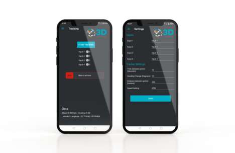
Touch GIS is a new mobile application that's helping to simplify field data collection for remote projects.
The software runs both online and offline, allowing for a wide range of geographic information features, which allows it to act as your primary mobile data collection system. Some of these features include vector (point, line and polygon) drawing, offline workflow, custom feature classes, and multi-project management. The app also offers easy importing and exporting so that the information can be shared on desktop software.
Currently, the application is available through Apple's app store for iPhone and iPad, with annual licensing plans available through the Touch GIS website. This includes options for individuals at $299.99/user, for small teams of five to nine at $284.99/user, and for larger teams of 10 or more at $269.99/user.
Image Credit: GISUser.com/CanadianGIS.com/Touch GIS
Why This Trend Is Growing
- Mobile Geospatial Data Collection
- Develop mobile applications that simplify field data collection for remote projects with offline workflow, custom feature classes, and multi-project management features.
- Vector Drawing Applications
- Create applications that enable easy vector (point, line and polygon) drawing offline and online for geographic information presentation, sharing and analysis.
- Desktop-mobile Data Collaboration
- Design software that allows easy importing and exporting of field data between mobile apps and desktop software for collaboration and sharing purposes.
Industries Being Reshaped
- Geospatial Technology
- Develop geospatial technology that can be powered by mobile applications with affordable pricing and packed with user-friendly features to streamline data collection and analysis.
- Environmental Monitoring & Assessment
- Create environmental monitoring and assessment tools for remote project sites using mobile applications that enable users to collect geospatial data, analyze, and share on handheld devices.
- Surveying & Mapping
- Introduce surveying and mapping technology that utilizes mobile applications to simplify data collection for field crews, with custom feature classes, multi-project management, and offline workflow tools.