


How Pedestrian Friendly Is Your Community?
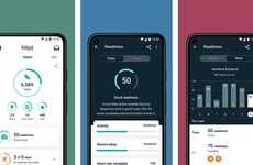
A new calculator lets people determine how pedestrian-friendly their neighbourhoods are. The tool is effective for the health-conscious in the housing market who wants to know the fitness factors involved with their new home purchase.
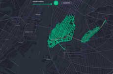
The site caters to residents of the United States, Canada and UK, and uses regional maps to trace the best walking routes from homes to businesses, coffee shops, restaurants, pubs, schools, libraries, parks, rec centers and more.
Implications - In order to achieve an accurate neighbourhood walk score it is important to consider that your Walk Score is calculated based on how at ease you are with walking distances.
Trend Themes
1. Walking-friendly Neighborhoods - Opportunity for real estate developers to create walking-friendly neighborhoods based on the growing demand for walkable cities and healthy lifestyle.
2. Map-based Walk Route Planning - Opportunity for technology companies to develop map-based walk route planning software that helps people find the best walking routes from homes to businesses, parks, schools, and other destinations.
3. Fitness-friendly Living - Opportunity for fitness and wellness industries to create products and services that cater to health-conscious customers who value walking as part of their daily routine.
Industry Implications
1. Real Estate - Real estate companies can leverage the trend of walking-friendly neighborhoods to develop and market properties that offer healthy and sustainable living options.
2. Technology - Technology companies can capitalize on the trend of map-based walk route planning by creating innovative software and apps that help people locate walking-friendly locations and plan their routes accordingly.
3. Health and Wellness - Health and wellness industries can create products and services that cater to the growing demand for fitness-friendly living concepts, such as walking as a daily exercise routine.
1.2
Score
Popularity
Activity
Freshness