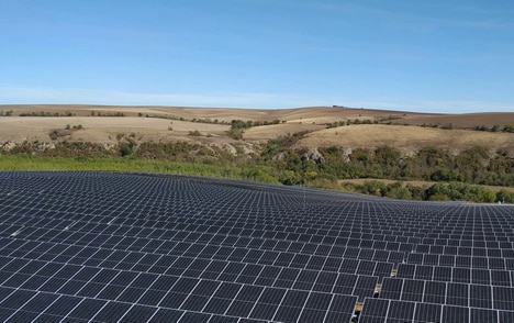
Xoople, a Spanish space startup founded in 2019, is building a satellite constellation to deliver high-quality optical data for AI models, featuring sensors to be manufactured by L3Harris. The company said its systems are designed to produce a continuous stream of precision imagery intended as ground truth for deep learning and enterprise workflows.
The firm closed a $130 million Series B led by Nazca Capital and named investors including CDTI and Endeavor Catalyst; it has raised $225 million to date. Xoople has integrated with cloud providers and is embedding distribution into platforms such as Microsoft and Esri while it finalizes its own on-orbit sensors.
For enterprises, the offering promises near-real-time monitoring for crops, infrastructure, supply chains and disaster response, simplifying AI training with consistent, platform-ready data. By pairing proprietary sensors with platform distribution, Xoople aims to make high-fidelity geospatial datasets more directly usable for commercial AI applications.
Image Credit: Xoople
Key Themes Behind This Trend
- Continuous High-fidelity Imagery
- A steady stream of precision optical data from dedicated constellations enables AI models to be trained and validated on consistent, time-series ground truth at enterprise scale.
- Sensor-platform Vertical Integration
- Combining proprietary sensor manufacturing with embedded distribution in cloud and GIS platforms creates end-to-end geospatial data stacks that reduce friction between capture and consumption.
- Near Real-time Enterprise Geospatial Services
- Rapidly refreshed satellite imagery tailored for commercial workflows permits timely monitoring of dynamic assets such as crops, infrastructure, and supply chains.
Where This Applies
- Precision Agriculture
- High-cadence, calibrated optical datasets support crop health modeling and yield forecasting with improved spatial consistency compared with sporadic public imagery.
- Insurance and Risk Management
- Frequent, high-resolution ground truth imagery enables more accurate damage assessment, parametrized risk models, and faster validation of claims after extreme events.
- Logistics and Supply Chain Monitoring
- Near-real-time visibility of transport nodes and routing corridors provides granular situational awareness that can reshape inventory planning and disruption forecasting.