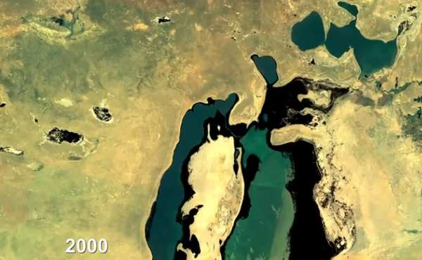
It doesn’t matter where you live, you have never surveyed a view as good as this: the stunning Landsat earth images are taken by satellites that have been sent up into space continually by NASA since July 23, 1972.
Capturing stunning photography for about three decades now, the seventh Landsat is doing its job to send back spectacular snapshots of what our world looks like from the void. Doing well to document the change natural disasters bring to our landscape, as well as the growth of urban sprawl, the project is as resourceful as it is accessible. Anybody who would like access these one-of-a-kind images, amongst other data, can pay a fee of $600.
In addition to public access, there is an annual exhibition, ‘Earth as Art’ to preview such pieces, as well as an online store for anybody interested in poster art.
What's Driving This Trend
- Satellite Imaging
- The use of satellite imaging technology to capture high-quality and stunning Earth images from space presents an opportunity for businesses in mapping, agriculture, weather, and defense sectors to improve their services.
- Data Visualization
- The ability to access and view Landsat images data as well as other satellite images brings an opportunity for businesses involved in data analytics, mapping, and city planning areas to develop tools that improve the visualization of large data sets.
- Remote Sensing
- The use of satellites for remote sensing and data collection creates opportunities in mining, environmental monitoring, oil and gas exploration, and military industries to expand their operations and improve business outcomes.
Who This Affects Most
- Mapping
- The high-quality earth images captured by landsat presented mapping industry with an opportunity to develop 3D mapping technology and improve their surveying and cartography services.
- Agriculture
- The ability to gather information from thousands of miles in space provides farmers with an opportunity to increase yields, optimize water usage and field management thus creating low-cost, large-scale solutions for feeding the population.
- Weather Forecasting
- The use of satellite imaging technology presented meteorological industries with an opportunity to improve forecasting accuracy and their decision-making processes in response to natural disasters such as fire, flood, and hurricanes.